Then and Now Take Two – Birmingham

This is a regular series of blogs about photographs of the same place taken years apart. I quite like those Then and Now comparison photographs that you see in books or on the Twitter or Facebook.  The first of the posts in this series was of a council building in Manchester.

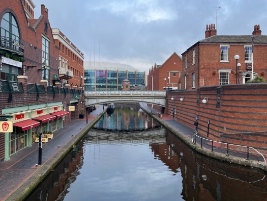
Next door to the ICC in Birmingham is a canal and there is a bridge across there from Brindley Place, and it would appear quite often when crossing the bridge I would take a photograph down the canal looking towards the what was the NIA (National Indoor Arena) and is now known as the Utilita Arena Birmingham.

I have over the years taken a photograph from the bridge. This was the view in May 2011 in the early evening.

In the preceding years the NIA had undergone refurbishment and renovation and had had a glass facade added. It was renamed the “Barclaycard Arena” in November 2014 after Barclaycard won the naming rights. This was the view in March 2015 over lunchtime.

Here we are four years later in October 2019 in the morning.

This photograph was taken in March 2020, also in the morning.

I wasn’t in Birmingham in 2021 due to lockdown, but was back in March 2022.

This is the scene in the morning.

This is the scene in the evening.

My most recent visit was in March 2023.

Canal

It’s quite surprising how little has changed over the twelve years between the photographs.

It would also not surprise you that I have a similar set of photographs looking the other way…

Then and Now – Birmingham

This is a regular series of blogs about photographs of the same place taken years apart.

I quite like those Then and Now comparison photographs that you see in books or on the Twitter or Facebook.

I always think I should give them a go. However what I have started to notice is that I have been doing Then and Now photographs unintentionally over the years and have been taking photographs of the same thing or place from the same view or perspective years apart.  The first instance of this that I noticed was in May 2019 when I went to  Manchester.

It only really came to my attention that I was doing this a lot, when checking the Places function on the Apple Photos Mac App that I could see I had taken the same photograph of the same thing just years apart!

Next door to the ICC in Birmingham is a canal and there is a bridge across there from Brindley Place, and it would appear quite often when crossing the bridge I would take a photograph down the canal looking towards the what was the NIA (National Indoor Arena) and is now known as the Utilita Arena Birmingham.

This was the view in May 2011 in the early evening.

In the preceding years the NIA had undergone refurbishment and renovation and had had a glass facade added. It was renamed the “Barclaycard Arena” in November 2014 after Barclaycard won the naming rights. This was the view in March 2015 over lunchtime.

Here we are four years later in October 2019 in the morning.

Finally on my most recent visit to Birmingham in March 2020, also in the morning.

It’s quite surprising how little has changed over the nine years between the photographs.

It would also not surprise you that I have a similar set of photographs looking the other way…

Walking along the canal

With all the beautiful weather we decided to take advantage of it and go for a walk along the Kennet and Avon Canal, well part of it anyhow.

The Kennet and Avon Canal is a waterway in southern England with an overall length of 87 miles, made up of two lengths of navigable river linked by a canal. The name is used to refer to the entire length of the navigation rather than solely to the central canal section. From Bristol to Bath the waterway follows the natural course of the River Avon before the canal links it to the River Kennet at Newbury, and from there to Reading on the River Thames. In all, the waterway incorporates 105 locks.

The two river stretches were made navigable in the early 18th century, and the 57-mile (92 km) canal section was constructed between 1794 and 1810. In the late 19th and early 20th centuries, the canal gradually fell into disuse after the opening of the Great Western Railway. In the latter half of the 20th century the canal was restored in stages, largely by volunteers. After decades of dereliction and much restoration work, it was fully reopened in 1990. The Kennet and Avon Canal has been developed as a popular heritage tourism destination for boating, canoeing, fishing, walking and cycling, and is also important for wildlife conservation.

We decided to do the walk as my eldest had gone on a school trip (as part of curriculum enrichment) in 2015 and had recommended it to us.

We caught the train to Avoncliff Halt.

Seriously this is a halt, and the platform is only big enough for a single carriage, so we had to make sure we were at the front of the train. Originally opened in 1906.

What looks like a road bridge is in fact part of the Avoncliff Aqueduct.

The Avoncliff Aqueduct crosses both the Wessex main line and the River Avon.

It was built between 1797 and 1801

There was this lovely house alongside the canal.

Very peaceful walking along in the shade. Though to be honest there were a fair few cyclists and other walkers as well.

Quite a few boats as well.

This is the Dundas Aqueduct, again built between 1797 and 1801.

The aqueduct is also the junction between the Kennet and Avon Canal and the largely derelict Somerset Coal Canal. The short stretch of the Somerset Coal Canal still in water forms Brassknocker Basin, used for boat moorings, cycle hire and a cafe.

Whilst we were walking along, two military helicopters, probably on their way to RNAS Yeovilton flew past, relatively low. One was a Puma, the other a Merlin.

As we got near the city centre of Bath, we went through two amazing tunnels.

Overall quite a trek, but great weather, lovely scenery and rather peaceful.